|
|
| Home |
| About CAST.IRON |
| Our Plans |
| Story so Far |
| Opposition |
| Case for Rail |
| Milton Road station |
| In the News |
| Photo Archive |
| Contact Us |
Follow us on Twitter:
@CAST_IRON_INFO
Links:
NoGuidedBus.com
Travelling the Busway blog
Site maintained for archival purposesCAST.IRON - Stage 2 (Detail)Click here for summary plans for Stage 2. 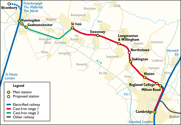 Stage 2 extends to CAST.IRON network to Huntingdon and thus provides a rapid public transport system between settlements from Cambridge to Huntingdon. 1. Service and SpecificationsThe Stage 2 service will follow the pattern of Stage 1B: 15 minute peak interval during weekday rush hour periods; 30-60 minute service interval at other times. To provide this service, two more trains will be leased, preserving the peak service interval on the longer system. All construction will be to the same technical specifications as in Stage 1B. 2. Route OptionsThe route from Cambridge to St Ives is a protected, recent railway corridor. In contrast, the former route from St Ives to Huntingdon has been disused since 1959. There are a number of route options for extending the railway from St Ives to Huntingdon. Of the various possibilities, two options are discussed here. 2.1. The Former A14The road building schedule recommended by the CHUMMS study includes a new Huntingdon southern bypass. A new section of A14 will be built south of the current A14, leaving the current route near Fen Drayton. The current A14 will then be 'de-trunked'. CHUMMS proposed that one carriageway of the de-trunked section between St Ives and Huntingdon be reallocated for public transport use. Provided that the Huntingdon southern bypass is in fact built, CAST.IRON therefore proposes that the railway route should run along this former A14 carriageway. A second platform will be built at St Ives. At St Ives trains will reverse and run southwards on a new viaduct behind the existing A1096 St Ives bypass road viaduct. The route will cross over the A1096 on a bridge at Galley Hill and then run onto the north carriageway of the former A14. This route allows a station to be provided at Godmanchester, where a passing loop will be built. The route ends at a Stage 2 Huntingdon terminus adjacent to Mill Common and close to the bus station. The whole route is shown below as route [1]. 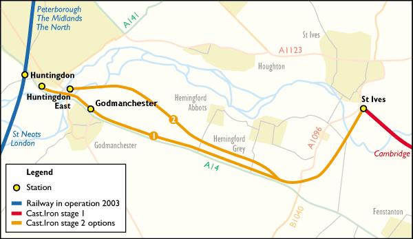 2.2 A14 Avoiding RouteIn the event that the current A14 does not become de-trunked, an alternative would be to make partial use of the former railway trackbed. Despite the date of its abandonment, nearly all of the trackbed of the former route remains preserved as an undeveloped strip of land, with practically all of the old embankments still in place. The A14 avoiding route shown as [2] above starts on the outskirts of Huntingdon, with the Stage 2 terminus adjacent to the Huntingdonshire District Council depot. The terminus would actually be just in Godmanchester, being across the river from Huntingdon. However it is within 500m of Huntingdon town centre (and hence closer than the existing Huntingdon station). From this terminus, route [2] uses 2km of the former trackbed. It then leaves this trackbed and runs south of the Hemingfords. The route joins option [1] to cross over the A1096 at Galley Hill. Of the two options above, option [1] is to be preferred on a number of grounds: it provides service to Godmanchester; it runs into the centre of Huntingdon and it makes maximum use of land already in transport use. There are also other route options that could be considered. Next - Stage 3 [summary] [detail] Site last modified April 2026
Tweet
|